Super El Niño in November ’26: What to Expect
By: Chandu Visweswariah
In 1877-1878, a Super El Niño event killed 50 million people. Scientists say that the probability of a super El Niño in November of 2026 is 100%, and that ocean temperatures will be hotter than in 1877’s event (see image above). This prediction is truly remarkable! When is the last time you heard scientists forecast a rare event with a hundred percent probability? Especially a future event that’s slated to be extremely damaging and represents “uncharted territory?” Never, right? Let’s understand what all this means.
The tropical Pacific Ocean oscillates between El Niño (literally “little boy” in Spanish, also called El Niño de Navidad since it tends to occur in December) and La Niña (“little girl,” also called El Viejo “old man”) events every 2 to 7 years, each episode lasting about 9 months, with neutral periods in between. El Niño years occur more frequently than La Niña. They represent opposite phases of the El Niño Southern Oscillation (ENSO) cycle and are fundamentally repeating patterns of fluctuating ocean temperatures and winds, which in turn have profound impacts on terrestrial weather.
El Niño represents the warm phase of the Pacific Ocean. Trade winds, which push warm water south towards Asia and Australia, are weaker. Thus, warm water “sloshes” back north and east towards the Americas, causing surface waters in the central and eastern Pacific to become warmer than usual. Jet streams also shift, bringing heavy rains to the southern U.S., but droughts to Australia and southeast Asia.
La Niña is the cold phase with stronger-than-usual trade winds pushing warm water towards Asia and Australia. Thus, the central and eastern Pacific near the Americas is cooler than usual, bringing drier conditions in that region, but heavier rainfall in southeast Asia and Australia.
Bottom line: For us in the Americas, an El Niño year means warmer temperatures and more rain. La Niña means cooler waters and droughts. This YouTube explainer video is helpful if you’d like to learn more.
But what does global warming have to do with this pattern that has been repeating for tens of thousands of years? Basically, natural cycles are playing out in a world with an unnaturally warm baseline. This makes impacts more intense. Warmer temperatures exacerbate the storms and hurricanes of El Niño and worsen the droughts of La Niña (and the opposite in the southern hemisphere). This worsening is consistent with everything we know about how global warming accentuates extremes of all kinds of weather patterns.
A Super El Niño means an exceptionally strong phase of the El Niño Southern Oscillation. The National Oceanic and Atmospheric Administration (NOAA) prefers the term “Very strong El Niño” to “Super El Niño.” Either way, a Super El Niño is declared when the ocean temperature in the eastern Pacific is 2°C (3.6°F) above normal. Take a look at global ocean temperatures during the last 30 years. The last two Super El Niños were in 1997 and 2015, and 2026, despite a cool start, looks like it will handily eclipse them!
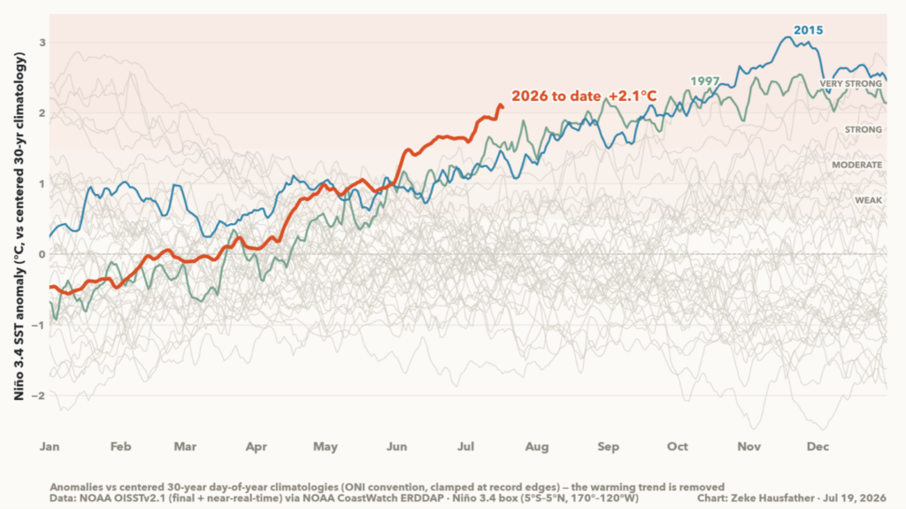
The ocean warmed 2.1°C (3.8°F) in July of 2026, and 2.6°C (4.8°F) as of the first week of August (not shown in graph) as I type this blog. Since warming of 2°C (3.6°F) triggers the Super El Niño prediction, you can now see why scientists are so confident. In a Super El Niño, vast subterranean masses of warm water called Kelvin waves supercharge the atmosphere. All El Niño impacts are accentuated: spiking temperatures, heavy rain, flooding, droughts and crop failures. Unfortunately, warmer waters also accelerate coral bleaching. What can we expect in November 2026?
Five such events have occurred in known history. The last “very strong” El Niño event was in 2015 when the tropical Pacific averaged 2.4°C (4.3°F) of warming. It caused a record 16 tropical cyclones and a 500-year drought in the Caribbean. 2015’s record for globally warm ocean water was broken in 2016, and then again in 2023, and now soon to be broken again in 2026 both globe-wide and in the Pacific!
The 1982-1983 El Niño was also “very strong.” Trade winds practically collapsed and reversed, causing weather disasters on every continent, leading to 2,000 deaths and more than $13 billion in damages.
But what’s coming later this year is being compared to the strongest recorded El Niño in 1877-1878, which caused widespread famine that killed 50 million people. In North America it was called “the year without a winter!”
Here’s the bottom line: the oceans are already unusually hot this year. The natural El Niño cycle will combine with warmer temperatures to create unusual extremes: storms, temperature spikes, floods, droughts, forest fires, coral bleaching, crop failures and property damage. We are in uncharted territory. Said Zeke Hausfather, a climate scientist at Berkeley Earth, “We should be preparing right now for something that we have never seen before… This event is so far outside of anything we’ve experienced.”
Since the 1960s, Super El Niño events are occurring more frequently, so we may face many more in our future. There is even speculation that we are building towards Mega El Niño temperature increases as great as those that caused the End-Permian extinction 252 million years ago.
Meanwhile, our anti-science leaders in Washington continue to claim that greenhouse gases are harmless, continue to kill renewable energy projects, continue to denigrate climate science and continue to incentivize fossil fuel use.
You can keep up to date with the latest ENSO forecasts from Columbia University at https://iri.columbia.edu/our-expertise/climate/forecasts/enso/current/. The only upside of such a confident forecast is that it gives us time, and very little wiggle room for debate, to start preparing for the worst.
This is an opinion and analysis article. The views expressed by the author are solely his own and not those of any organization he is affiliated with or CURE100.